
Short-Loop Trails - Southern Region Brochure (PDF)
Anthony Chabot: Woolridge Loop

Route: (shown in orange)–Start at the Woolridge Staging Area and head north through the pipe gate and onto the trail. Follow the fire road on the right for about 100 yards until you see the post marking Goldenrod Trail. Take Goldenrod left until it meets Jalquin Trail. Turn left onto Jalquin Trail back towards the staging area Description: This scenic loop showcases much of what Anthony Chabot has to offer. As you walk the Goldenrod Trail you will find yourself surrounded by dense plant life including native conifers, oaks, grasses, wildflowers, and the ever-present eucalyptus. Enjoy this wooded, shady stretch, and watch for raptors above, squirrels below, and deer all around. As you ascend onto the high ground of the Jalquin Trail, enjoy the spectacular views to the east overlooking Grass Valley Creek. Trail type: natural, fire road. Trail condition: smooth. Amenities at trailhead: information, parking. Amenities on trail: trash can, water. 1.91 miles. Elevation gain: 280 feet. Maximum grade: 14%.
Brushy Peak: East Side Out-and-Back

Route: (shown in green)–From the staging area restroom walk north to the trailhead that’s located just to the left of the residence. This will take you to the Brushy Peak Loop Trail. Walk along this trail until it takes a sharp left hand bend and goes uphill. This is your turn around point. Description: This walk in Brushy Peak takes you up high, providing great views of the surrounding grasslands and a perfect perch for birdwatching. Red tailed hawks and golden eagles are common here, as are ground squirrels, owls, reptiles, badgers, and the San Joaquin kit fox. The structural remnants alongside the trail are what’s left of farm buildings built by Joseph Laughlin in 1920s and 1930s. Trail type: natural, fire road. Trail condition: smooth. Amenities at trailhead: parking, information, restrooms. Amenities on trail: none. 2.3 miles. Elevation gain: 320 feet. Maximum grade: 10.7%.
Brushy Peak: West Side Out-and-Back

Route: (shown in orange)–From the parking area head back across the road (west) to the gate and start up the West Side Loop Trail. Continue until you reach the gate before turning around to complete the full hike. Description: Much like its sister hike, the West Side Walk provides hikers with great views of the adjacent valley and surrounding grasslands, as well as the opportunities to see native birds and ground mammals. Look closely at the various grasses and plant species that are present, and notice how they change depending on their position in the valley, and how much water is available. Trail type: natural, fire road. Trail condition: smooth. Amenities at trailhead: parking, information, restrooms. Amenities on trail: none. 1.8 miles. Elevation gain: 140 feet. Maximum grade: 8.6%.
Coyote Hills: Tuibun Village Loop

Route: (shown in orange)–From the Visitor Center, head east on Bayview Trail, which becomes the Tuibin Trail. Then turn left onto the Chochenyo Trail at the entry kiosk, and when the Chochenyo splits, bear left to see the Tuibin Village site. Continuing your walk, go right for a short disance, then left, with the Main Marsh on your left. Go to the paved Bayview Trail, turn left, and complete the loop. Description: The Tuibun Village Loop takes you through rich marshlands and to a 2,000-year-old Ohlone village site, complete with replicated structures. Trail type: paved and natural, narrow. Trail condition: smooth. Amenities at trailhead: Visitor Center, picnic areas, water, parking, phone, information. Amenities on trail: none. 2.5 miles. Elevation gain: 50 feet. Maximum grade: 3%.
Garin: Dry Creek Trail Out-and-Back

Route: (shown in green)–Begin from the Garin Barn Visitor Center and head south on Jordan Pond Loop towards Jordan Pond. Turn left onto the paved beginning of the Dry Creek Trail and follow it, bearing left at the first junction, and right at the second to avoid the rougher parts of the trail. Walk until you get to the gate at Meyers Ranch Trail and turn back for your return. Description: This longer walk provides opportunities to see wildlife, grasslands, and chaparral areas in Garin and Dry Creek Regional Parks. Attentive walkers may see raptors soaring overhead, lizards and squirrels underfoot, and butterflies all around in season. Dry Creek Trail is mostly shaded as it courses along the canyon bottom. Trail type: natural and paved, fire road and narrow. Trail condition: rustic. Amenities at trailhead: Visitor Center, restrooms, benches, trash cans, recycling, information, phone, drinking water, parking, horseshoes, picnic tables. Amenities on trail: picnic areas, trash cans, benches, fishing. 2.2 miles. Elevation gain: 245 feet. Maximum grade: 10%.
Route: (shown in orange)–Begin from the Garin Barn Visitor Center and head south towards Jordan Pond. Take the trail around the pond and back to the parking area. Description: This quick loop around Jordan Pond takes you past popular picnic and lawn areas. You’ll see the historic Visitor Center, with artifacts from the ranching and farming history of the Hayward area inside, and a variety of antique farm equipment on display outside. As you make your way around the lake, you may see squirrels, raptors, and lizards, as well as a variety of wildflowers in the spring and early summer. Trail type: natural, fire road and narrow. Trail condition: smooth. Amenities at trailhead: Visitor Center, restrooms, benches, trash cans, recycling, information, phone, drinking water, parking, horseshoes, picnic tables. Amenities on trail: picnic areas, trash cans, benches, restrooms, fishing. .75 miles. Elevation gain: 50 feet. Maximum grade: 8%.
Hayward Shoreline: Cogswell Marsh Loop

Route: (shown in orange)–From the parking area, head south and continue out into Cogswell Marsh. This a “lollipop” loop and you will soon be walking the head of the lollipop. Do not turn south when you reach the footbridge at Johnson’s Landing. Instead, pass the footbridge and go north to complete the lollipop loop and return to the parking area. Description: The Cogswell Marsh Loop provides users with an intimate bay experience. Thanks to an ever-present bay breeze and buffer from the city, it’s easy to forget that you’re at the center of a great megalopolis. Keep an eye out for least terns, and be sure to read the information signs that tell the interesting history of this marshland restoration. Trail type: dirt and gravel. Trail condition: good. Amenities at trailhead: parking, information, restrooms. Amenities on trail: information, benches. 2.75 miles. Elevation gain: 0 feet. Maximum grade: 0%.

Route: (shown in orange)–Start at the Martin Luther King, Jr., Grove off Swan way and head north along the Arrowhead Marsh Trail. When you reach the observation deck walk towards it and cross the small bridge before turning right onto San Leandro Creek Trail West. Walk along this path until you can see a right turn that will take you back to the Arrowhead Marsh Trail and complete the loop. Description: The New Marsh Loop takes you around a portion of Martin Luther King Jr. Regional Shoreline’s 71-acre restoration project filled with recolonized native plants and returning bird species. Take note of the attractive picnic and lawn areas, and the observation tower–perfect for birdwatching or a view of the entire park. Trail type: paved. Trail condition: good. Amenities at trailhead: parking, restrooms, picnic facilities, benches. Amenities on trail: benches, information, observation tower. 2.02 miles. Elevation gain: 0 feet. Maximum grade: 0%.
MLK Shoreline: San Leandro Creek Trail Loop
Route: (shown in green)–Start at the Elmhurst Staging Area on Elmhurst Drive and head southwest, towards San Leandro Bay, along the Elmhurst Creek Trail. Turn left at the San Leandro Creek Trail East. Walk this path to Hegenberger Road and take the sidewalk to San Leandro Creek Trail West to head back to Elmhurst Creek Trail and the parking area. Description: This flat, paved trail follows San Leandro Creek for about a mile and offers walking options to Arrowhead Marsh and Garretson Point trails. Along the banks of the creek there are many types of migratory waterfowl for your viewing pleasure, and looking to the west you can see the San Francisco skyline. This loop trail is best done during high tide. Trail type: paved. Trail condition: good. Amenities at trailhead: parking, restrooms, information, drinking water, wheelchair access. Amenities on trail: benches, information, restrooms, picnic areas, observation tower. 1.91 miles. Elevation gain: 0 feet. Maximum grade: 0%.
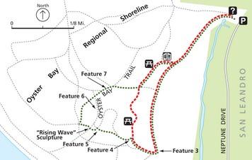
Route: Begin at the Neptune Drive parking area and head west, following the paved trail south. Turn right at Feature 3, the “Oyster Bay History” interpretive panel. At Feature 4, the “Native Plants” interpretive panel, turn right for the shorter loop (shown in orange), continue until you see the restrooms, turn right, and then left on the path back to the parking area. For the longer loop (shown in green) continue past Feature 4 and to the sculpture. Turn right past the sculpture, and right again at the first pathway. Head back to the paved path and go left, back to the parking area. Description: On this quick loop you may notice restored marshlands, and are sure to see ground squirrels, several bird species, and butterflies. Trail type: paved and dirt. Trail condition: fair to good. Amenities at trailhead: parking, drinking water, information. Amenities on trail: benches, restrooms. .75/.97 miles. Elevation gain: 80/100 feet. Maximum grade: 5%/7%.
Quarry Lakes Horseshoe Lake Loop

Route: (shown as a green dotted line)–Begin at the boat ramp and take Old Creek Trail south and make the loop with Horseshoe Lake to your left. Complete your walk on the Western Pacific Trail and return past the swim beach to your starting point. Description: This loop is a great introduction to Quarry Lakes and what it has to offer. Enjoy views of the lake with the beautiful hills to the east as a backdrop, and explore the fishing dock and boat launch, swim area, volleyball courts, and picnic areas. Length: 2.1 miles. Trail type: natural and paved, fire road. Trail condition: smooth. Amenities at trailhead: drinking water, benches, restrooms, picnic, recycling, phone, volleyball. Amenities on trail: drinking water, restrooms, benches, fishing, swimming. Elevation gain: 100 feet. Maximum grade: 4%.
Quarry Lakes Rainbow Lake Loop
Route: (shown as an orange dashed line)–Start at the southernmost end of the parking lot (nearest the lake). Take the Californio Trail and walk the loop around Rainbow Lake. Description: This loop takes you around smaller Rainbow Lake on slightly quieter trails compared to those around Horseshoe Lake. These trails present a perfect place to slow down and view the wildlife in this popular recreation area. Keep an eye out for a variety of birds, ground mammals, and insects. Length: 1.3 miles. Trail type: natural and paved, fire road. Trail condition: smooth. Amenities at trailhead: drinking water, benches, restrooms, picnic, recycling, phone, volleyball. Amenities on trail: drinking water, restrooms, benches, fishing. Elevation gain: 0 feet. Maximum grade: 4%.
Shadow Cliffs: Levee/North Arroyo Trail Loop

Route: (shown in green)–Start at the west end of the first parking area past the park entry kiosk. Take your first left onto the Levee Trail at the top of the levee. Continue along the Levee Trail until you see a trail drop down to the right near the end of the water . Drop down onto the North Arroyo Trail to return to the start. Description: This walk starts out by dropping down to Arroyo area and follows the shoreline where many types of ducks, geese, and birds may be seen. It then circles a very pretty pond with cattails and cottonwoods before returning to the levee trail for views of Shadow Cliffs lake with its kayaks, fisherman, and many types of waterfowl. Trail type: fire road. Trail condition: good. Amenities at trailhead: none. Amenities on trail: benches. 1.31 miles. Elevation gain: 90 feet. Maximum grade: 7%.
Route: (shown in orange)–Start at the west end of the first parking area past the park entry kiosk. Head away from the pavement and take your first right towards the marsh. Follow this trail around the marsh. Description: This gentle, rolling levee trail circles a small woodland area (formerly a marsh) with slightly elevated views. This is a great place to see nesting birds and hear their pleasant songs. It follows the Arroyo Del Valle, where many ducks and geese feed and play. Trail type: fire road. Trail condition: good. Amenities at trailhead: none. Amenities on trail: benches. .71 miles. Elevation gain: 53 feet. Maximum grade: 5.5%.
Shadow Cliffs: South Arroyo Trail Loop
Route: (shown in blue)–Start at the west end of the first parking area past the park entry kiosk. Take your first left onto the Levee Trail at the top of the levee and continue east. Soon after walking past the last of the parking lots and fishing docks, you will see a narrow trail on the left. This will take you down to the waterfront, where you follow the paved Lake Trail back to the parking area. Description: This trail offers commanding views of the Del Valle Arroyo to the west and Shadow Cliffs lake to the east. As you make your way on the levee trail you loop back past numerous fishing docks, where you can find out what’s biting. You then meander along the lakeshore, where many recreational opportunities await. Trail type: fire road and paved. Trail condition: good. Amenities at trailhead: none. Amenities on trail: benches. 1.2 miles. Elevation gain: 60 feet. Maximum grade: 11%.
Sunol: Indian Joe Nature Trail Loop
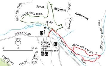
Route: (shown in orange)– From the Visitor Center, head over the footbridge and turn right onto Canyon View Trail. Continue past the first trail–Hayfield Road–cross a usually dry stream bed, and at the second trail junction past the stream turn left onto the Indian Joe Creek Trail. After a short distance turn left, cross Indian Joe Creek onto the Indian Joe Nature Trail, which will return you to a right turn onto Canyon View to return to the footbridge. Description: A short walk along a cottonwood-bordered stream that gently climbs through a wooded canyon with terrain typical of Bay Area hills. Borrow a booklet from the Visitor Center (open weekends only) to interpret this self-guided nature trail. Trail type: natural, narrow. Trail condition: smooth, with rough sections. Amenities at trailhead: parking, Visitor Center (open weekends only), information, restrooms, benches, picnic areas, phone. Amenities on trail: bench. .91 miles. Elevation gain: 100 feet. Maximum grade: 13.5%.
Route: (shown in green)–From the Visitor Center, head over the footbridge and turn left. Turn right onto Shady Glen Trail and continue to a right turn onto Hayfield Road. Turn right again at Canyon View and return to the footbridge. Description: Short, steep grades with narrow switchbacks that reach a grassy upland with sweeping views of Flag Hill and the nearby canyons. Sunol is home bald and golden eagles, mountain lions, bobcats, deer, and tule elk. Trail type: natural, narrow. Trail condition: smooth, with rough sections. Amenities at trailhead: parking, Visitor Center (open weekends only), information, restrooms, benches, picnic areas, phone. Amenities on trail: none. .98 miles. Elevation gain: 185 feet. Maximum grade: 22%.