
Overview
Park Hours:
5 a.m. - 10 p.m.
Gate Hours:
November - February: 8 a.m. - 5 p.m.
March - May: 8 a.m. - 6 p.m.
June - September: 8 a.m. - 7 p.m.
October: 8 a.m. - 6 p.m.
Visitor Center Hours:
Wednesday through Sunday, 10 a.m. - 4 p.m.
Parking: No fee
Fees subject to change
69 Big Break Road Oakley, CA 94561
Visitor Center Mailing Address: 69 Big Break Road, Oakley, CA 94561
(510) 544-3050
1-888-EBPARKS (888-327-2757)
Internet & Cellular Access

Public WiFi is available at the Visitor Center.
Check AT&T, T-Mobile & Verizon Coverage.
Select 'Map Layers' and switch on 'No Data Coverage Areas'
Big Break Regional Shoreline is a part of the great 1150-square-mile Sacramento-San Joaquin River Delta. The water flowing past Big Break through the Sacramento and San Joaquin-the State's two greatest rivers-drains half of California and creates the largest estuarine environment on the Pacific coast. This area is also referred to as the "Inland Coast."
Big Break was once an upland farm, now submerged. It is a small bay or estuary at the edge of the San Joaquin River, and lies in the zone where salty seawater meets snowmelt and runoff from the Sierra Nevada mountains. The mixing of salty and fresh water produces an "edge effect" increasing habitat and species diversity. It makes Big Break a fine home or stopover spot for a wide variety of species, particularly birds and fish.
Big Break is home to 70 species of birds and several species of mammals. Twenty-seven special-status wildlife species have the potential to occur within the parkland; six special-status wildlife species are known to occur. Nesting is confirmed or suspected for black rails, northern harriers, white-tailed kites, and yellow-breasted chats. Many wading birds, including great blue herons, great egrets, snowy egrets, green herons, and white-faced ibis, forage in the tidal sloughs and freshwater marshes. These areas also provide habitat for Western pond turtles, a California Species of Special Concern. Big Break is a suitable breeding habitat for turtles, and females can lay their eggs in the sandy banks and well-drained upland soils. The tidal sloughs, freshwater marsh, and riparian areas also provide valuable habitat for beavers, muskrats, and river otters, which forage and potentially den at Big Break.

Big Break Naturalist Programs
Join us for our monthly programs!
To Reach The Park
Maps
Park Accessibility
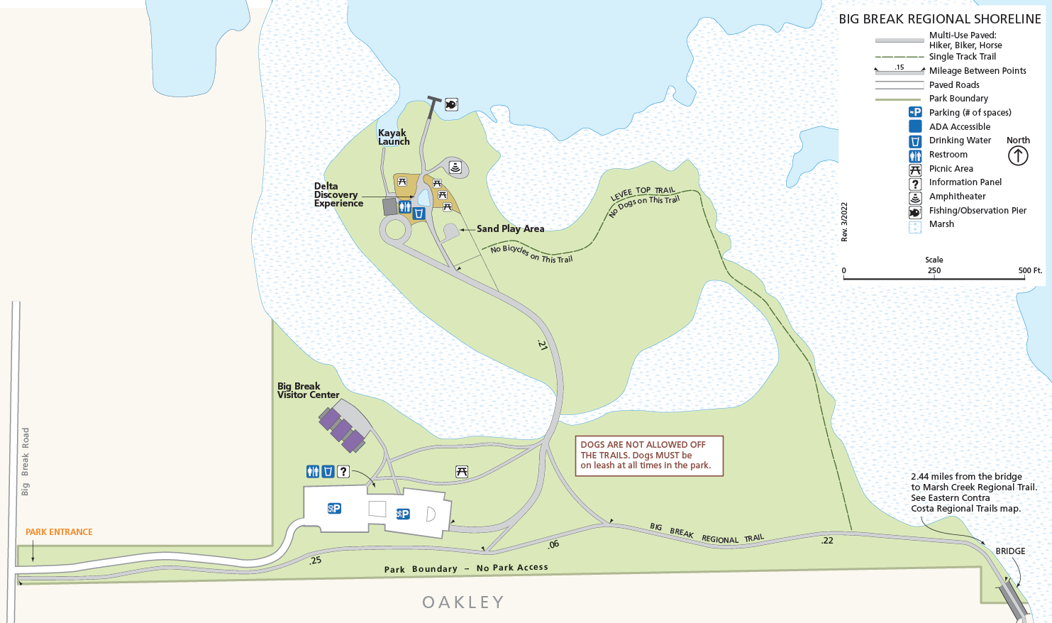
The Big Break Regional Trail is paved and relatively flat. Wheelchair accessible drinking fountains and a wheelchair-friendly restroom are located adjacent to the trail.
Attractions
Big Break Visitor Center at the Delta
The newest Park District Visitor Center, Big Break Visitor Center is located in the area of the park accessible from Big Break Road. The visitor center includes temporary displays about the Delta and is staffed by Park District naturalists who can give information about the park and specific activities in the area including wetland walks and adjoining trails. Big Break Regional Shoreline offers picnic and meadow areas, a small, shaded amphitheater, boat and kayak launch facilities (an official San Francisco Bay Water Trail trailhead), a fishing and observation pier, and spectacular Delta views.
Completed in 2012, the interpretive center building is certified 3 Green Globes by the Green Building Initiative for green building design, engineering, construction, and facility operations. The 5,500-square-foot pre-fabricated building project was partially funded by a $2.5 million grant from the State of California's Proposition 84.
Shoreline and Delta Discovery Experience
Big Break Regional Shoreline also includes the Delta Discovery Experience, an “interpretive landscape” depicting the Delta watershed. Highlighted by a 1,200-square-foot interactive scale map of the Delta, the “DDX” allows visitors to see how water flows into and through the region. The map was designed, fabricated and installed by Scientific Art Studio, based in Richmond, California.
Big Break visitor Sutter O'Steen, age 7, explores the Delta map in this homemade video.
Many park users come to Big Break simply to enjoy cool Delta breezes in the summer. Birdwatchers are drawn by the constant birdsong from the marshes, and everyone comes to enjoy easy access to the beautiful Delta waterfront.
Fishing
The 100-foot fishing pier is very popular with local anglers. A California fishing license is required to fish from the pier or shoreline, but an EBRPD fishing access permit is not required. While shore fishing offers less success, boaters offshore catch primarily largemouth bass and striped bass, with some white catfish, bluegill, sunfish, and sturgeon also caught.
Boating
Kayakers and canoeists can access the waters of Big Break from the on-site beach launch, a ¼ mile walk from the parking lot. Boaters enjoy Big Break due to its proximity to the rivers and sloughs of the Inland Coast with access from local marinas and launches. See our Boating page for more information.
Swimming
There is no swimming allowed at Big Break Regional Shoreline.
Hiking and Biking
The Big Break Regional Trail, which runs along the southern edge of Big Break through the Ironhouse Sanitary District, provides access for hikers, bicyclists, and equestrians to the southeastern edge of the estuary. The trail connects to the northern end of the Marsh Creek Regional Trail, providing access to Brentwood and Oakley. The Marsh Creek Regional Trail connects to the Delta de Anza Regional Trail via West Cypress Road, providing access to Oakley, Brentwood, Antioch, Pittsburg, and Bay Point.
Naturalist Programs
Park Naturalists conduct a variety of programs for both organized groups and the public. Programs are offered on a variety of subjects including Delta history and current issues, birding, wetland ecology, and general nature exploration. Public programs, usually on weekends, are publicized in the Park District's bi-monthly newsletter, Regional In Nature, which is also available in the visitor center or by browsing “Activities” under EBParks.org/Register. Weekday field trips and programs are available for schools and organized groups by reservation. Please see our Educators Resources information here or call (510) 544-3050 for further information.
Detailed descriptions of Naturalist Programs.
History
The area's first inhabitants were Native American tribes who lived in the Bay Area for the last 10,000 years. Spanish explorers arrived in 1772, and French trappers arrived in 1832, attracted to the same abundant wildlife that had sustained the Native Americans. They collected beaver pelts for the European tophat trade. Mountain men such as Jedediah Smith explored the area, and the Chinese built farming levees in the Delta after laying the first railroad tracks through the Sierra Nevada. Portuguese, Italians, Dutch, and other nationalities were also drawn to the area. Seagoing ships navigated the rivers transporting supplies, tallow and exporting furs.
The entire Delta was dramatically transformed by the California Gold Rush, which accelerated the settlement of the Delta and the substantial land reclamation that changed the Delta area's environment. Unsuccessful Forty-Niners returned to the Delta from the Motherlode to farm the rich soils. Because of the annual flooding, they erected crude levees. In the 1870s, the clamshell dredge enabled farmers to erect more stable and extensive levees.
By 1930, Delta reclamation was almost complete, with some 57 man-made islands encompassing over 550,000 acres. To this day, agriculture is the primary land use, particularly the production of dry grains, asparagus and other specialty crops. The name "Big Break" comes from a 1928 break in the levee that separated an asparagus farm from the San Joaquin River and Dutch Slough.


