Overview
November - February: 8 a.m. - 4 p.m.
March: 8 a.m. - 5 p.m.
April: 8 a.m. - 6 p.m.
May - August: 8 a.m. - 7 p.m.
September: 8 a.m. - 6 p.m.
October: 8 a.m. - 5 p.m.
Park curfew: 10 p.m. - 5 a.m.
Parking: No fee
851 Waterbird Way, Martinez, CA 94553.
Toll Free: 888-EBPARKS (888-327-2757), option 3, extension 4566
Internet & Cellular Access

Check AT&T, T-Mobile & Verizon Coverage.
Select 'Map Layers' and switch on 'No Data Coverage Areas'
Park Activities
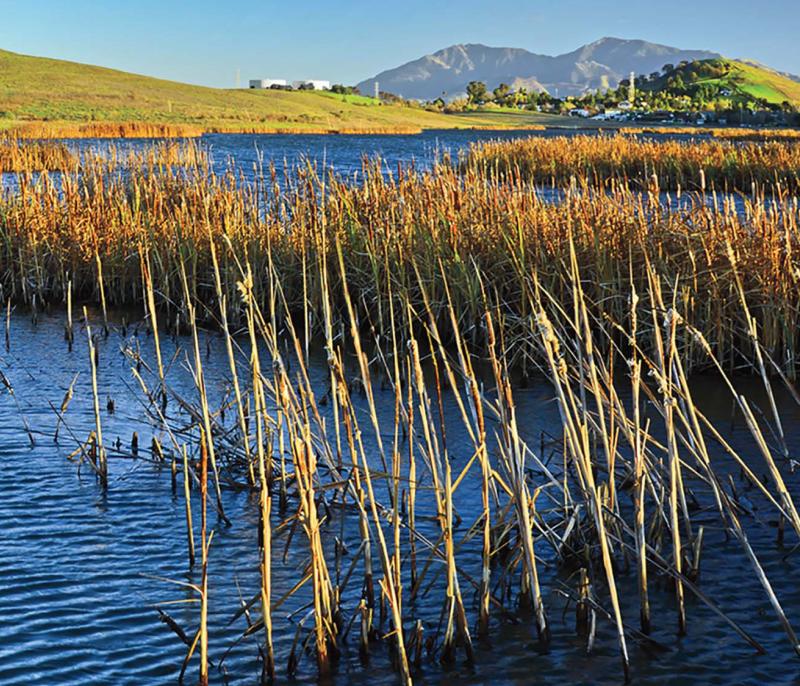
Waterbird Regional Preserve is a 198-acre area comprised of a wetland and the associated uplands to the east. The focal point of the Preserve is the rich and diverse Al McNabney Marsh, of which the East Bay Regional Park District owns 46 acres in the southern end and Mountain View Sanitary District owns 69 acres in the northern and deeper end.
Notice: No dogs allowed.
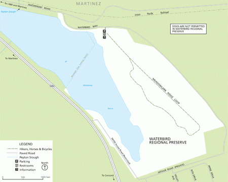
To Reach The Park
Maps
Attractions
McNabney Marsh and the uplands area of Waterbird Regional Preserve provide habitat for a variety of birdlife and offer good opportunities for birders to view species ranging from waterbirds to raptors.
Waterfowl and shorebirds use the marsh for foraging and nesting, and the uplands areas are home to small mammals such as ground squirrels and pocket gophers. The patient birdwatcher may see birds ranging from the American avocet, killdeer, and great blue heron to the American kestrel, western meadowlark, cedar waxwing, and great horned owl. Familiar waterbirds observed in the marsh area include the American coot, mallard, green-winged teal, black-necked stilt, bufflehead, Canada goose, cinnamon teal, and white pelican. Other common birds seen at the Preserve include the barn swallow, black phoebe, Brewer's blackbird, cliff swallow, European starling, Say's phoebe, house finch and house sparrow.
This is only a partial listing of the many bird species that are resident or are expected to visit this Preserve. The lucky birder may also see the white-tailed kite, northern harrier, golden eagle, osprey, and peregrine falcon.
Birdwatching
McNabney Marsh lies on the Pacific Flyway for migratory birds and is home to many species of waterfowl and shorebirds. The fall and spring migrations bring an abundance of waterfowl as they stop to rest and feed on their flights north or south.
Hiking
The Preserve also provides hiking opportunities in the several miles of trails in the uplands area. Take the trail out of the parking area to reach the Meadowlark Ridge Loop for good views of the marsh. Walk to the northern end of the park towards the pepperwood trees to see signs of the old housing site dating from the early 1900s.
In the future, the trail system in Waterbird Regional Preserve is expected to connect to the proposed Point Edith-to-Martinez Shoreline Regional Trail, which will connect the Preserve to trails in the nearby Peyton Hills Marsh operated by the State Lands Commission.
Dogs
Please note that due to the fragile nature of the marsh ecosystem and the presence of feeding and breeding waterbirds, DOGS ARE NOT PERMITTED anywhere in Waterbird Regional Preserve.
Fishing and Water Contact
Fishing is not permitted in Waterbird Regional Preserve. McNabney Marsh contains treated, reclaimed water. Water contact of any kind is prohibited.
Upcoming Events
History
The area now known as McNabney Marsh was first visited by the Bay Miwok's Chupcan people, a tribelet thought to have consisted of about 200 people. With the plentiful resources of the bay, marshlands, and uplands, these Native Americans were able to sustain their existence here for centuries, until the influx of explorers and missionaries in the 1800s.
The construction of a major rail line through the area in the 1880s helped define the marsh as we see it today. The shipping and rail services of Martinez encouraged the location of the Peyton Chemical Company and the Mountain Copper Company at the mouth of Peyton Slough. The uplands area of the Preserve with pepperwoods and eucalyptus was most likely the site of early nineteenth-century chemical company worker housing. The pepperwoods line an old road made of "clinker" stones, produced through smelting operations.
McNabney Marsh, named after a former leader of the Mt. Diablo Audubon Society, is part of a larger 200-acre wetland complex connected by Peyton Slough, which drains into Suisun Bay. In 1988 an oil spill inundated marshlands in this area, including McNabney Marsh. Following that spill, a $10 million Natural Resource Fund was established to restore, rehabilitate and acquire the equivalent of the natural resources damaged by the oil spill. The East Bay Regional Park District acquired 198 acres in the south end of the marsh in 1992 using funding provided by the Trustee Committee overseeing the Natural Resource Fund. This land included the uplands to the east of the marsh, which provide recreational trail opportunities today.