Overview
November - February: 7 a.m. - 6 p.m.
March - October: 7 a.m. - 10 p.m.
Parking: No fee
No parking for school buses or chartered buses. Drop-offs and onboarding only.
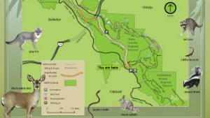
Sibley Main Staging Area: 6800 Skyline Blvd. Oakland, CA 94611
Old Tunnel Road Staging Area: Quarry Road, Orinda, CA 94564, GPS: 37.856197, -122.206485
Eastport Staging Area (formerly Wilcox Station Staging Area): Pinehurst Road, Orinda, CA 94563, GPS: 37.839806, -122.181444
Toll Free: 888-EBPARKS (888-327-2757), option 3, extension 4554
Internet & Cellular Access

Public WiFi is not available.
Check AT&T, T-Mobile & Verizon Coverage.
Select 'Map Layers' and switch on 'No Data Coverage Areas'
Park Activities
Cattle grazing has been part of the ecosystem in the East Bay hills since the 1800s and in Sibley for many decades and part of the East Bay’s ecosystem for many tens of thousands of years. Grazing is important to removing hazardous vegetation to reduce wildfire risks and maintaining and improving natural habitat for plants and wildlife.
Visitor Tips:
- Keep dogs on leash in areas where cattle are present.
- If cattle are blocking the trail, approach slowly, speak normally, and allow them to move away.
- Cows are protective of their calves. Do not try to get close, touch, or pet them.
- Close pedestrian gates behind you.
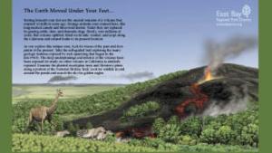
East Bay residents have a volcano in their backyard at Sibley Volcanic Regional Preserve. Originally called Round Top Park, Sibley shares with Temescal and Tilden the distinction of being one of the East Bay Regional Park District's original parks. The preserve was later named in honor of Robert Sibley, who helped found the District and served for 10 years on its board of directors.
To Reach The Park
Maps

Park Accessibility
Round Top Road is paved to the top of Round Top. (Watch for occasional vehicles using the road.) There is also a 600-foot, paved wheelchair path north of the visitor center that ends at a viewing platform. Quarry Road, beginning at Old Tunnel Road, is also paved.
Attractions
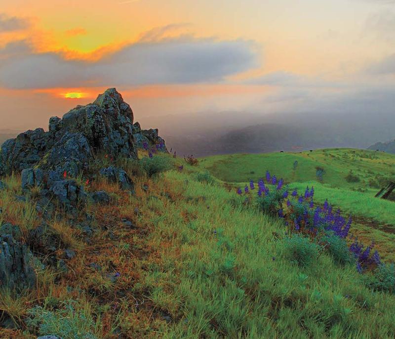
Round Top (elevation 1763 ft. above sea level) is the preserve's most prominent feature.
The unstaffed visitor center at the Skyline Boulevard staging area has displays illustrating the preserve's geology. A self-guided brochure is available at the staging area highlighting the preserve's geological features.
Several trails provide access throughout the preserve. The 31-mile East Bay Skyline National Recreation Trail, part of the Bay Area Ridge Trail system, traverses the preserve along the ridgeline between Wildcat Canyon and Anthony Chabot Parks. Round Top Road goes from the Sibley visitor center to the top of Round Top. Round Top Loop Trail circles Round Top peak. Volcanic Trail, once a quarry haul road, contains most of the stops on the self-guided volcanic tour.
From Old Tunnel Road on the northwest side of the park, the paved Quarry Road ascends and meets the east end of Volcanic Trail. Quarry Trail connects the middle of Volcanic Trail to a point lower down on Quarry Road. Finally, Pond Trail is a short trail segment that descends to a couple of ponds on the north side of the preserve.
Park Activities
Most trails are hiking and equestrian only. A few trails are multi-use. Dogs are permitted at Sibley, but are not allowed on adjacent Huckleberry trails. A visitor center at the park shelves self-guided tour brochures so guests can stroll the park and learn of its historic significance at their own leisure.
Bicycles are not allowed on narrow-gauge trails, except on the Skyline Trail between the Sibley visitor center and Old Tunnel Road. Bicycles are allowed on the wider-gauge fire trails and paved roads, but are not allowed on Round Top Road from the fork .15 mile east of the visitor center to the top of Round Top.
The Sibley Backpack Camp is a small, primitive hike-in site for a maximum of 15 campers, a 0.2 mile walk uphill from the parking lot. Site has 2 picnic tables (1 ADA), 1 serving table, and a pit toilet. Reservations are required and must be made 2 or more business days in advance. View the Camping page for more information, and call Reservations to reserve.
Upcoming Events
History
Round Top, one of the area's highest peaks, is made up of lava and volcanic debris left over from a 10-million-year-old volcano. During the past 10 million years, massive tectonic forces on the Hayward and Moraga earthquake faults uplifted the Berkeley hills, folding bedrock formations and tilting the Round Top volcano complex on its side.
Softer sedimentary rock from the Orinda Formation eroded away, exposing the Round Top volcano. In addition, quarrying in the north half of the preserve has revealed cross sections of the bedrock geology, providing an unsurpassed outdoor laboratory for studying volcanism in the Central Coast Ranges.