
Overview
Ohlone College Entrance/Parking lot: Daily, year-round, 6 a.m. - 10 p.m.
Stanford Avenue Entrance/Parking Lot: Dec. 23 - Mar. 31, 6:30 a.m. - 8 p.m.; Apr. 1 - Dec 22, 6:30 a.m. - 9 p.m.
Ohlone Entrance: 43600 Mission Blvd., Fremont
Stanford Avenue Entrance: Stanford Avenue Staging Area
(510) 544-3247
Toll Free: 888-EBPARKS,
(888) 327-2757, option 3, extension 4545
Camping Reservations: 1-888-EBPARKS or (888) 327-2757, option 2
Internet & Cellular Access

Check AT&T, T-Mobile & Verizon Coverage.
Select 'Map Layers' and switch on 'No Data Coverage Areas'
Park Activities
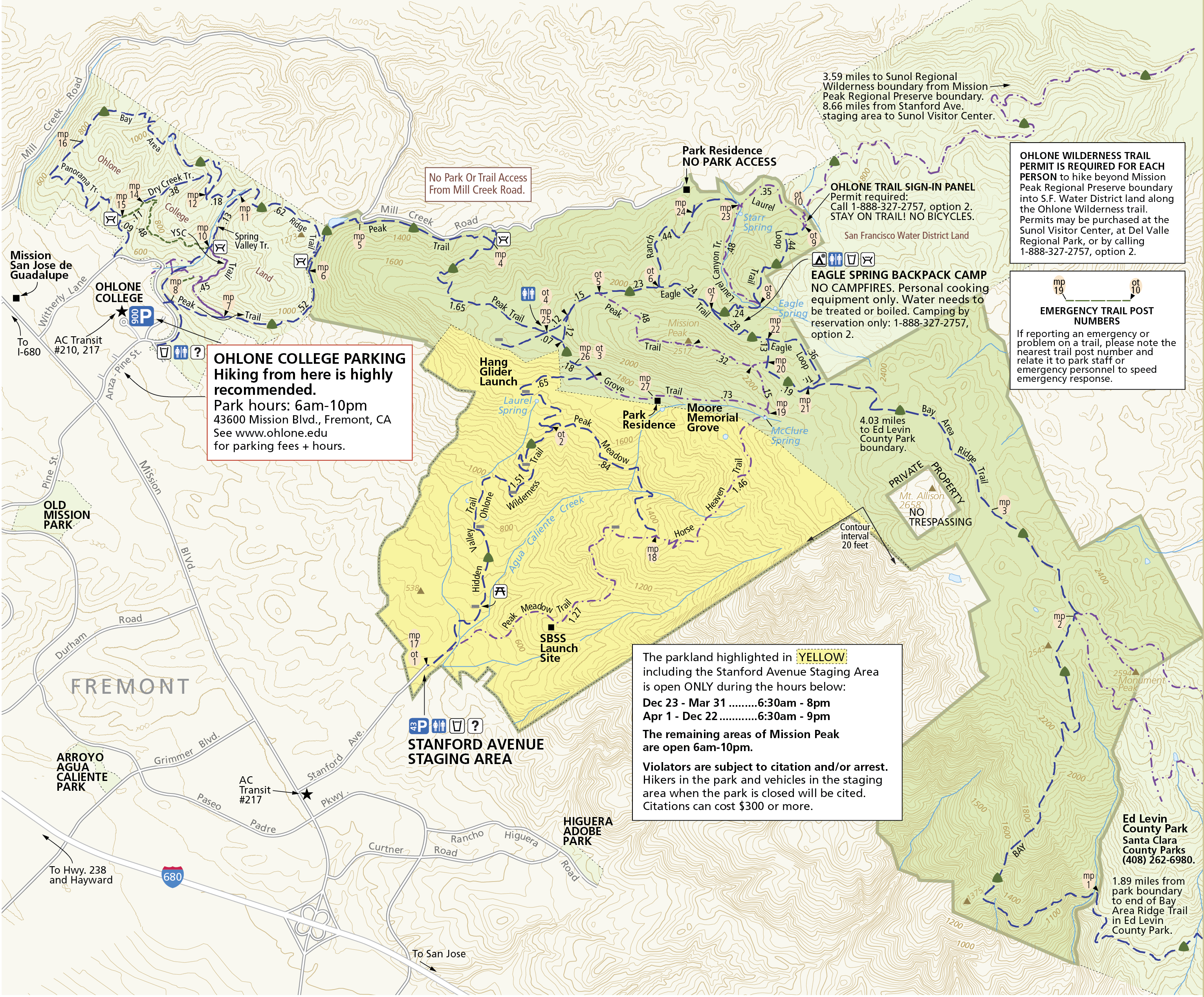
Rising steeply to the east of the city of Fremont, Mission and Monument peaks form a dramatic backdrop to the South Bay. The determined and conditioned hiker who reaches the top of Mission Peak will be rewarded with views of Mount Hamilton to the south, the Santa Cruz Mountains to the west, Mt. Tamalpais to the north, and Mt. Diablo and the Sierra Nevada to the northeast. Hawks and vultures share the summit airspace with sailplanes riding the thermals, and a down-to-earth herd of feral goats roams the cliffs.
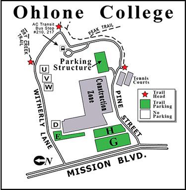
This well used park, particularly on weekends, with hundreds of visitors attempting the 3-plus-mile hike to Mission Peak. About five hours are required to reach the summit and return. This parkland's 3,023 acres are accessible from parking lots at Ohlone College (slightly longer hike, but more gradual ascent; plenty of parking on weekends) or from a small staging area at the east end of Stanford Avenue in Fremont (steep climb to the summit; parking lot is extremely congested on weekends). There is no access to the park from Mill Creek Road.
The Peak Trail from Ohlone College is an enjoyable hike to the summit that passes a horse corral and through shaded woodlands and open grasslands. This trail is part of the Bay Area Ridge Trail, a planned 550+-mile multi-use trail (currently over 330 miles are complete) along the hill and mountain ridgelines ringing the San Francisco Bay Area. The college charges a $4 parking fee. Parking lot vending machines take cash or credit cards. See the Ohlone College parking information webpage to confirm fee information.
The Stanford Avenue staging area is also the western access to the Ohlone Wilderness Trail, a 29-mile hiking and riding trail through some of southern Alameda County's most beautiful wilderness. Permits are required to hike in the Ohlone Wilderness.
Park Hours
Ohlone College
Entrance/Parking Lot
43600 Mission Blvd., Fremont
Accessible by RideShare
Over 900 parking spaces
Daily, year-round
6 a.m. - 10 p.m.
Stanford Ave.
Accessible by RideShare
Parking permit program for residents
Entrance/Parking
43 parking spaces
Dec. 23 - Mar. 31
6:30 a.m. - 8 p.m.
Apr. 1 - Dec. 22
6:30 a.m. - 9 p.m.
NO Public Access to Mission Peak from Mill Creek Road.
Please note that hours are strictly enforced. Visitors found inside the park, entrance area, and parking lot after posted hours will be subject to citation and or arrest. Citations cost a minimum of $300
To Reach The Park
Maps
Attractions
Safe Hiking Tips
Every year, several dogs die of heat stroke and dehydration at Mission Peak and many hikers suffer injuries, as well. Consider these tips while hiking in the park:
Water, Water, Water!!!
- Bring at least 2 liters of water for you and your dog.
- Make sure your companions also have enough water.
- Offer water to your dog every time you drink some.
Be Sun Smart
- Wear a hat and generously re-apply sunscreen.
- Avoid hiking in the middle of the day in the summer months.
Dog Health and Safety
- Dogs are much more susceptible to heat stroke than humans. Hike with your dog only in cooler temperatures.
- Take rests and offer water frequently.
- Watch for signs of heatstroke, which include heavy panting, dry gums, weakness, and inattention.
Sturdy Footwear
- Hiking boots and athletic shoes with ankle support are recommended! [PDF]
- Thick socks help minimize blisters and absorb moisture.
- Do not wear flip-flops, sandals or high heels.
Trail Restoration
Restoration of “The Scarface” Continues!
The Park District continually works to remove bootleg trails and restore the natural beauty of the hillside near the Mission Peak summit, where it’s been eroded over the years due to hikers leaving the designated trail. We’ve installed fences and signs to educate the public and direct hikers to stay on the marked paths.
Please help the restoration effort by staying on the marked trails. Do not take shortcuts. Press release on restoration work, 2014.
Preserving the beauty of Mission Peak
Irvington High School student volunteers, members of the Mountain Goats bicycle club, and District staff helped restore more than ½-mile of trail in 2012 and 2013. They installed fencing, jut net blankets, eco-wattles, and grass seeds, in hopes of stabilizing the slope and preventing erosion. They also installed signs to educate visitors about the importance of staying on marked trails, and the efforts underway to protect the park’s natural beauty.
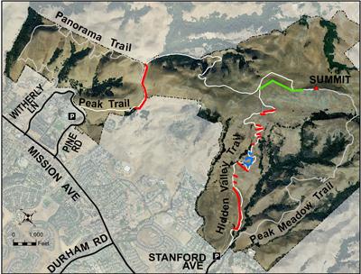
BLUE = 2012 Restoration
RED = 2013 Restoration
GREEN = 2014 Restoration
How can you help?
For more tips and volunteer opportunities, see "A Restoration Story" and Mission Peak Needs Your Help!
- Stay on designated trails
- Avoid entering restoration areas
- Avoid creating new “bootleg” trails
Other Challenging Trails
If you enjoy the challenge of the Hidden Valley Trail, try these challenging hikes.
Hiking, biking, dog walking, and horseback riding are popular activities available in the Regional Preserve.
Interpretive Hikes
The interpretive staff at Coyote Hills Regional Park leads organized hikes along the slopes and the peak. For information on these and other naturalist-led activities, call the Coyote Hills Visitor Center at (510) 544-3220.
Backpack Camping
Eagle Spring Backpack Camp offers backpack camping opportunities. Reservation is required. All water should be treated or boiled before drinking. Reservations are required and must be made 2 or more business days in advance. View the Camping page for more information, and call Reservations to reserve.
Radio Control (R/C) Flying
Remote-controlled aircraft can be launched at R/C Hill only. All remote-controlled pilots launching at R/C Hill must be members of South Bay Soaring Society (SBSS) and must have in their possession a current membership card. No motorized or gas-powered aircraft are allowed. No other sites within Mission Peak Regional Preserve are approved for this activity.
Hang Gliding and Paragliding
The Wings of Rogallo hang gliding club has a launch site at Mission Peak Regional Preserve to conduct hang gliding and paragliding activities.
Upcoming Events
Resources
Wildflower Photo Guides
- District Wildflower Photo Guide [PDF]
- District Wild Plant Photo Guide [PDF]
- Mission Peak - Calflora Plant List
- Mission Peak - PlantID.net ID Guide