
Short-Loop Trails - Northern Region Brochure (PDF)
Bay Point Regional Shoreline: Harrier Loop
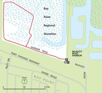
Route: (shown in orange) Take the Harrier Trail west into and through the shoreline park.
Description: Bay Point Regional Shoreline is one of many wetland restoration projects undertaken by the East Bay Regional Park District. This shoreline park is a perfect place to observe some of the unique species that thrive in marsh habitat. At Bay Point Regional Shoreline you’ll find a variety of birds, including doves, hummingbirds, sparrows, and hawks, alongside a variety of plant life such as alkali bulrush, pickleweed, and salt grass.
Length: 1.11 miles.
Trail type: natural, narrow. Trail condition: smooth.
Amenities at trailhead: information, picnic tables, restrooms.
Amenities on trail: none.
Elevation gain: 30 feet.
Maximum grade: 2%.
Big Break: Delta Discovery Site Walk
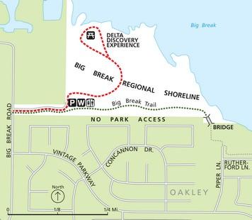
Route: (shown as an orange dashed line) Start from the parking lot and head north towards the pier, kayak launch, and the Delta Discovery Experience site. Explore, and return.
Description: This walk leads you to Big Break’s new Delta Discovery Experience site, where a large interactive map of the California Delta is laid into the ground for your exploration. There are also picnic areas, an amphitheater, kayak launch, and a 100-foot fishing pier.
Length: 0.60 miles.
Trail type: Paved. Trail condition: smooth.
Amenities at trailhead: parking, restrooms, information, benches, recycling.
Amenities on trail: fishing, benches, information, water.
Elevation gain: 0 feet.
Maximum grade: 0%.
Big Break: Marsh Walk
Route: (shown as a green dotted line) Take the Big Break Trail east from the parking area to the bridge and return.
Description: Enjoy a quick walk into the Delta marshland of Big Break Regional Shoreline. Keep an eye towards the sky for a variety of native bird species, and scan the marsh for wading birds like the great blue heron, white-faced ibis, and snowy egret.
Length: 0.70 miles.
Trail type: Paved. Trail condition: smooth.
Amenities at trailhead: parking, restrooms, information, benches, recycling.
Amenities on trail: none.
Elevation gain: 0 feet.
Maximum grade: 0%.
Briones: Abrigo Valley Trail
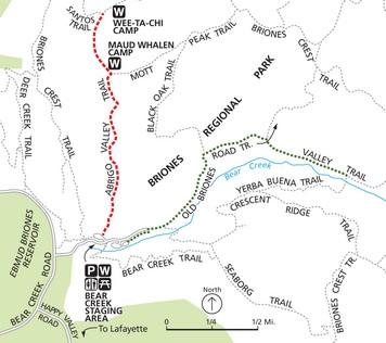
Route: (shown as an orange dashed line) From Bear Creek Staging, take the Abrigo Valley Trail to the Santos Trail and Wee Ta Chi group camp and return.
Description: More shaded than its sister hike along Old Briones Road Trail (see below), this walk offers some respite from the heat during warmer weather. Watch for lizards, ground squirrels, and raptors.
Length: 2.66 miles.
Trail type: natural and fire road.
Trail condition: smooth.
Amenities at trailhead: parking, picnic areas, restrooms, information, water.
Amenities on trail: benches, restrooms, water.
Elevation gain: 260 feet.
Maximum grade: 10%.
Briones: Old Briones Road Trail/Valley Trail
Route: (shown as a green dotted line) From Bear Creek Staging, take Old Briones Road Trail, then Valley Trail, to Yerba Buena Trail and return.
Description: A walk through open grasslands, following Bear Creek to the south. The unobstructed skyward views from Old Briones Road Trail make for great birdwatching, especially for raptors, which are a common sighting in the park.
Length: 3.02 miles.
Trail type: natural, fire road; Valley Trail is narrow.
Trail condition: smooth.
Amenities at trailhead: parking, picnic areas, restrooms, information, water.
Amenities on trail: none.
Elevation gain: 255 feet.
Maximum grade: 8.3%.
Carquinez Regional Shoreline: Overlook Loop
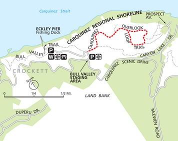
Route: (shown in orange) Start at the Bull Valley Staging Area and take the Carquinez Overlook Loop Trail.
Description: This walk high in the hills above Crockett affords trail users tremendous views of the Carquinez Strait to the north and Suisin Bay to the east. As you follow the undulations of the trail, keep an eye out for raptors and ground squirrels. Also be sure to enjoy the dense eucalyptus groves that provide much-appreciated shade on warmer days.
Length: 1.48 miles.
Trail type: narrow, fire road.
Trail condition: fair to good.
Amenities at trailhead: restroom, information, parking.
Amenities on trail: bench.
Elevation gain: 105 feet.
Maximum grade: 9%.
Contra Loma: Reservoir Loop
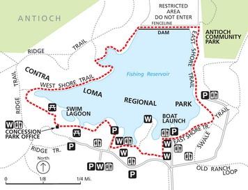
Route: (shown in orange) Begin at the concession/park office and walk west along the West Shore Trail. Follow this around the reservoir and cross the dam, then turn right and follow the East Shore Trail to the boat launch parking area on Ramp Road. Make a left and follow the road until you reach East Lake Road, then go right onto the West Shore Trail and return to your starting point.
Description: This walk takes you through an oasis surrounded by grassland and woodland foothills. The 80-acre reservoir features fishing and boating, with swimming in a separate lagoon. Contra Loma is a wintering ground for many migratory waterfowl, offering superb birdwatching opportunities. Over 150 species of birds have been sighted here, from the rare bald eagle to the California quail. Enjoy peaceful views across the reservoir, and contemplate the beauty of the California Delta and the Sierra foothills from the dam.
Length: 2.09 miles.
Trail type: natural and paved.
Trail condition: smooth, slippery when wet.
Amenities at trailhead: parking, water, restrooms, picnic areas, swimming, information, fishing.
Amenities on trail: information, benches, picnic areas.
Elevation gain: 23 feet.
Maximum grade: 10%.
Diablo Foothills: Castle Rock Trail Loop
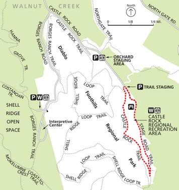
Route: (shown in orange)–From the trail staging parking lot walk south on Castle Rock Trail. Continue to the junction with Stage Road Trail, then turn left and head back towards the recreation area. Use the road to complete the loop and return to the parking area.
Description: This walk circumnavigates Castle Rock Recreation Area, where park guests have access to picnic facilities, a pool, the softball field and volleyball court, and other amenities. Diablo Foothills is home to an abundant wildlife population including raptors, deer, and ground squirrels.
Length: 1.1 miles.
Trail type: paved and natural, fire road and narrow.
Trail condition: smooth.
Amenities at trailhead: information, parking.
Amenities on trail: restrooms, shower, swimming, picnic areas, garbage, recycling, water.
Elevation gain: 120 feet.
Maximum grade: 13%.
Las Trampas: Bollinger Creek Loop
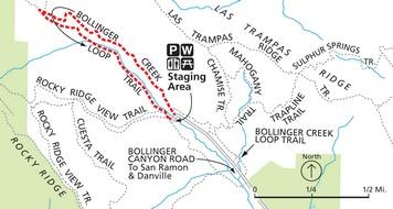
Route: Begin at the parking area at the end of Bollinger Canyon Road and go northwest on the Bollinger Creek Loop Trail. Continue on the loop trail, crossing the creek and returning on the opposite side.
Description: This walk takes you up a small canyon and into an oak/bay woodland, an ideal habitat for many species of birds. There are views of open grassland and steep ravines, and you will see a variety of trees including bay laurel, oak, and buckeye. The trail meanders alongside quiet and shady Bollinger Canyon Creek.
Length: 1.4 miles.
Trail type: natural, fire road and narrow.
Trail condition: variable.
Amenities at trailhead: parking, drinking water, information, benches, restrooms.
Amenities on trail: benches.
Elevation gain: 300 feet.
Maximum grade: 16%.
Martinez Shoreline: Killdeer/Duckpond Loop
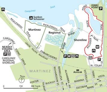
Route: (shown as an orange dashed line) North Court St. parking to Killdeer Trail to Duck Pond Trail, around pond, return to parking.
Description: This trek through Martinez Regional Shoreline takes you through the main park area–with picnic areas, a lawn, and play structures–and around the duck pond, which is home to birdlife year round. You’ll be able to enjoy views of the Carquinez Strait, restored marshlands, and sea birds.
Length: 0.95 miles.
Trail type: paved and natural, fire road and narrow.
Trail condition: good.
Amenities at trailhead: information, restrooms, parking, water at North Court.
Amenities on trail: benches, information, water.
Elevation gain: 0 feet.
Maximum grade: 0 %.
Martinez Shoreline: Pickleweed Loop
Route: (shown as a green dotted line) Parking at end of Berrellesa St. to Pickweed Loop Trail and back.
Description: This walk through Martinez Regional Shoreline starts by heading north from the parking area into restored marshland adjacent to Alhambra Creek. This important restoration, completed in 2002, was a joint effort of Caltrans, the City of Martinez, and the Park District. It provides important wildlife habitat and a great experience for visitors. As you continue west into the marsh, keep an eye out to your right (north) to sight a historic sunken schooner just offshore.
Length: 0.94 miles.
Trail type: paved and natural, fire road and narrow.
Trail condition: good.
Amenities at trailhead: benches, information, parking, restroom at parking area.
Amenities on trail: benches, information, water.
Elevation gain: 0 feet.
Maximum grade: 0%.
Miller/Knox Regional Shoreline: Pond Loop
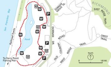
Route: (shown in orange) Park at any of the three large lots to access the trail.
Description: This relaxing walk around the pond is the perfect way to enjoy Miller Knox Regional Shoreline. Take extra time for a side trip south along the shoreline to the Ferry Point fishing pier to enjoy the bay. While enjoying views of San Francisco Bay, Mt. Tamalpais, and the Richmond-San Rafael Bridge to your right, you’ll notice the remains of an old rail line as you head south towards the pier. These tracks are evidence of the park’s past as the western terminus of the transcontinental railroad.
Length: 1.05 miles.
Trail type: paved, natural, fire road and narrow.
Trail condition: good.
Amenities at trailhead: water, play area, horseshoes, parking, information.
Amenities on trail: benches, water, restrooms, information, lawn.
Elevation gain: 0 feet.
Maximum grade: 0%.
Point Pinole: Bay View/Powerhouse Loop
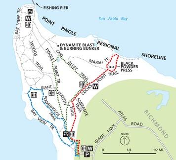
Route: (shown as a blue dashed and dotted line) Start at the parking area and go to the Bay View Trail to Powerhouse Trail to Pinole Point Trail to staging area.
Description: The Bay View Loop in Point Pinole explores the southwest portion of the park, initially dropping down towards the shoreline above San Pablo Bay. Here you’ll see ground mammals and enjoy open grasslands and shoreline habitat. As you climb up onto Powerhouse Trail for the return trip you’ll be rewarded with great views of San Pablo Bay to the west and Parchester Marsh to the south.
Length: 1.9 miles. Trail type: paved and natural, primarily fire road.
Trail condition: good.
Amenities at trailhead: parking, water, phone, benches, information, restrooms.
Amenities on trail: benches, restrooms, information, water, lawn areas, play structures.
Elevation gain: 138 feet.
Maximum grade: 11.5%.
Point Pinole: Cook’s Point Loop
Route: (shown as an orange dashed line) Start at the parking area. Walk from Giant Station Trail to Cook’s Point Trail to Marsh Trail and back.
Description: This walk to the shoreline takes you through impressive eucalyptus groves to the northeastern tip of the park, where you are treated to wonderful views of San Pablo Bay to the north and Whittell Marsh to the west. On the return trip, stop by the old black powder press and read the interesting history of Point Pinole.
Length: 2.52 miles.
Trail type: paved and natural, primarily fire road.
Trail condition: good.
Amenities at trailhead: parking, water, phone, benches, information, restrooms.
Amenities on trail: benches, restrooms, information, water, lawn areas, play structures.
Elevation gain: 111 feet.
Maximum grade: 5.7 %.
Point Pinole: Owl Alley/Cook’s Point Loop
Route: (shown as a green dotted line) Start at the parking area and take Pinole Point Trail to Owl Alley Trail. Go right at Cook’s Point Trail to Pinole Point Trail to the staging area.
Description: The Owl Alley Loop takes users around the interior of Point Pinole, starting up the paved Point Pinole Trail, which takes you past the maintained lawn areas, picnic sites, and recreation facilities. As you turn southeast on Owl Alley Trail you will walk along grasslands before entering a wooded area with eucalyptus planted by previous landowners.
Length: 2.27 miles.
Trail type: paved and natural, primarily fire road.
Trail condition: good.
Amenities at trailhead: parking, water, phone, benches, information, restrooms.
Amenities on trail: benches, restrooms, information, water, lawn areas, play structures.
Elevation gain: 123 feet.
Maximum grade: 5.7%.
Reinhardt Redwood: East Ridge Trail

Route: (shown as an orange dashed line) From Skyline Gate, take the East Ridge Trail; return at Eucalyptus Trail.
Description: East Ridge Trail, slightly more difficult than its sister trail (below), offers clear views of the valley. It’s perfect for birdwatching; watch for raptor species common to the area.
Length: 1.39 miles.
Trail type: natural, fire road.
Trail condition: smooth.
Amenities at trailhead: restrooms,
water, parking, information, phone, disabled access.
Amenities on trail: none.
Elevation gain: 190 feet.
Maximum grade: 8%.
Reinhardt Redwood: West Ridge Trail
Route: (shown as a green dotted line) From Skyline Gate, take the West Ridge Trail; return at French Trail.
Description: West Ridge Trail gently winds along the hillside at an average elevation of 1,300 feet, overlooking Redwood Creek below. Enjoy views to the northeast, and note the great variety of plant life.
Length: 1.12 miles.
Trail type: natural, fire road.
Trail condition: smooth.
Amenities at trailhead: restrooms, water, parking, information, phone, disabled access.
Amenities on trail: none.
Elevation gain: 70 feet.
Maximum grade: 4%.
Temescal: Loop Trail
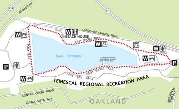
Route: (shown in orange) Start from the south-end parking lot near the park office and follow East Shore Trail past the swim area. Turn left onto Dam Trail. Continue to the staircase at the terminus of the West Shore Trail. Descend these stairs and continue on the West Shore Trail back to the parking area.
Description: This quick loop around Lake Temescal doesn’t disappoint. The East Shore Trail and Dam Trail offer plenty of places to sit and enjoy the scenery and watch people fish or enjoy picnicking. Swim at the swim beach (fee) in the warmer months. The secluded West Shore Trail takes you right along the shoreline, where you can enjoy redwoods and a lush riparian habitat. Lend an eye to the water and you’ll likely see fish swimming near shore, and several kinds of birds in their habitat.
Length: 0.93.
Trail type: paved path, narrow natural.
Trail condition: good.
Amenities at trailhead: water, restrooms, phone, picnic areas, parking, information, playground, fishing, swimming, disabled access.
Amenities on trail: benches, water, restrooms, picnic areas, fishing, information.
Elevation gain: 20 feet.
Maximum grade: 3%.
Tilden Nature Area: Jewel Lake Loop
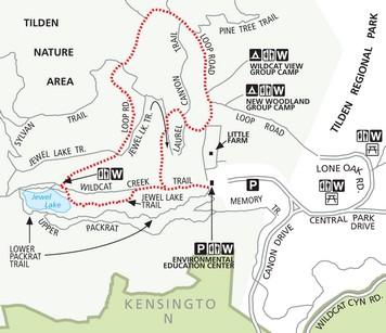
Route: (shown in orange)–Go north on Wildcat Creek Trail from the Environmental Education Center, then left onto the boardwalk (Jewel Lake Trail) to Jewel Lake. Follow Loop Road until just past Wildcat View Group Camp, turn right and go down the service road to Wildcat Creek Trail, then left to the parking lot.
Description: This shaded hike through the heart of Tilden Nature Area, with its 800-foot long boardwalk, serene Jewel Lake, and peaceful woodlands, is an escape from urban bustle. Please note that dogs are not allowed in Tilden Nature Area.
Length: 1.30 miles.
Trail type: natural, fire road, and narrow.
Trail condition: good.
Amenities at trailhead: parking, water, benches, information, bus stop, bike parking, playground, restrooms, Visitor Center, phone.
Amenities on trail: benches, drinking fountain.
Elevation gain: 160 feet.
Maximum grade: 10.7%.